Download our xPlane User Guide to help you get the most out of xPlane. This provides a step-by-step guide to help you find out about what kind of aircraft from Heathrow fly over your location, when and how often.
Download xPlane User Guide
Below you can find the answers to some commonly asked questions about xPlane.
Frequently Asked Questions
1. What is xPlane?
xPlane is a new tool which allows you to access flight data specific to your individual location and carry out your own analysis of flights over a selected area. Results will include the numbers, heights, position and types of aircraft.
2. How does xPlane get its data?
xPlane uses data from the Noise and Track Keeping system operated by Heathrow which captures data from the air traffic control radar.
3. How far from Heathrow can locations be selected?
xPlane works with locations out to 37 miles (60km) from Heathrow.
4. What air traffic is covered by xPlane?
xPlane provides information on arrivals and departures at Heathrow. Aircraft from other airports are not included.
5. Over what time period can I view flights over my area?
xPlane data includes all flights from the last five years. Please note there is a three day delay before flight data appears in xPlane.
6. Why does the number of flights change depending on what direction the gate is pointing?
Only flights that pass through the gate will be displayed. Flights that pass through the home zone (cone) but not the gate will not be displayed. Care is needed when selecting the rotation of the gate as it can significantly change the results shown.
7. Which “Apply” button should I use?
Both apply buttons function identically.
8. I have selected a different postcode/date but the flights have not changed. Why is this?
You will have to press the Apply button once again if you would like to see the different flights. This will refresh the data.
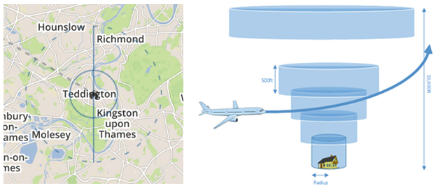
9. What is the difference between the solid circle and the dashed circle on the map?
The solid circle indicates the selected ground radius of the home zone and the dashed circle indicates the uppermost radius of the home zone. The home zone is set at a 45 degree angle from the ground radius.
10. How can I find out where I live in relation to Heathrow’s flights and the direction planes fly over my property?
There are a number of ways to find out how aircraft fly over your property. You can enter your postcode into Webtrak My Neighbourhood, download Heathrow’s annual flight maps or look at the flight maps on slides 6 and 7 of the xPlane User Guide.
11. The positions of aircraft over me on a specific date are different to the position of flights over me on the same date the previous year. Why is this?
The position and heights of aircraft over a particular area will vary from day to day depending on various factors such as weather conditions, safety, aircraft type, the departure profile used by the airline and the take-off weight. Air traffic controller directions will also affect a flight’s location.
12. How can I do a side-by-side comparison of flights from one date with flights from another date?
You can open up a separate xPlane window in a new tab in your internet browser and repeat all steps in the step-by-step guide with a different date selected. You can then switch between both tabs to view both results side by side. In the future we will look to enhance the tool by adding a function that allows you to view two time periods side by side.
13. How do I find noise data on xPlane?
xPlane provides information about the numbers, heights, position and types of aircraft over your property. It does not provide noise data. You can download noise exposure contours around London airports here. We are looking to enhance xPlane with noise data in subsequent releases of the product.